

Dresden – A City in 10,000 Images
Comprehensive documentation of the
urban and rural cityscape.
Location Dresden, Germany Client City Archive Dresden Production Time 2021-2024
As part of a Europe-wide tender, I was selected by the Stadtarchiv Dresden (Dresden City Archives) to document the city as an architectural photographer and project manager in 10,000 images. I have been documenting architecture since the beginning of my work as a photographer. Starting as a photojournalist, I have photographed my hometown of Leipzig from all angles since 2010. I have specialized in views from high-rise buildings and towers to show the city from unique perspectives.
In 2020, my project "Bellevue – Dresden from Above" was created, in which I documented Dresden with a drone in 111 aerial photographs from a strictly vertical bird's eye view. I have been continuing this series in Leipzig since 2021. My work as an architectural photographer has received numerous international awards and exhibitions. I focus particularly on large-scale projects, such as monographs on the complete works of architectural firms, collections of alpine mountain huts, Andalusian gas stations or snow-covered wind turbines.
This background and my ability to implement projects with strategic planning and an artistic eye were decisive factors in my selection by the Dresden City Archives. Between 2021 and 2024, we implemented the most extensive cityscape project in German history to date: comprehensive documentation covering all ten districts and eight localities, united in an archive of over 10,000 images.
What makes this project unique is not only the number of images, but also the innovative approach: each image was precisely tagged with GPS data and location information, a first in German cityscape photography. In addition, the complete release of rights and GDPR-compliant recording enables not only the city administration but also every citizen to use the images freely – a significant step for transparency and public accessibility.
This project is far more than a photographic inventory. It is a resource for administration, a tool for research and an instrument for public and economic development. But how is such extensive documentation planned and implemented? And why is it so valuable for the city? In the following video you will get a first impression – and in the following text you will learn how we realized this unique project and how it can serve as a model for other cities worldwide.
1. The Task: Goals and Requirements
The task is as clear as it is ambitious: Dresden is to be documented comprehensively, including all ten districts and eight localities. The aim is to create a comprehensive picture of the urban and rural cityscape that captures the structural and natural, historical and future-oriented levels as well as the infrastructural and cultural dimensions.
Main topics:
Public buildings such as schools, daycare centers, citizens' offices and police stations
Transport infrastructure including public transport, roads, sidewalks and bridges
Green spaces, parks, playgrounds and sports fields
Construction developments such as new buildings, renovation projects and infill developments
Signs of the energy and transport transition: solar and wind energy, e-mobility, shared mobility
Legal certainty and transparency: GDPR-compliant anonymization of individuals and vehicle license plates, as well as clear regulation of usage rights, are integral components of the project. This allows the images to be freely used not only by the administration, but also by citizens under the Creative Commons license CC-BY-SA 4.0.
Technical requirements:
All photographs are taken orthogonally (i.e. without converging lines) and neutrally in daylight to ensure consistent quality. These are city overviews, not detailed shots of buildings, to clearly represent the overall picture of the urban and rural cityscape.
The images are taken exclusively from public land, guaranteeing legally compliant use. This corresponds to the criteria of freedom of panorama, which permits the photographing and publishing of works that are permanently visible in public spaces.
Data Enrichment: Each image is supplemented with metadata that includes the following information:
Location (street name, house number, district)
GPS coordinates and altitude data
Time of recording
Building types and usage categories
Integration of mandatory subjects: A list of mandatory subjects is being created in close cooperation with the Dresden City Archives and the city councillors. Some of these subjects come from the historical image collection of the archive, while others reflect current topics and development projects.
This clear objective and the structured requirements lay the foundation for the successful implementation of the project and the creation of a valuable image archive.
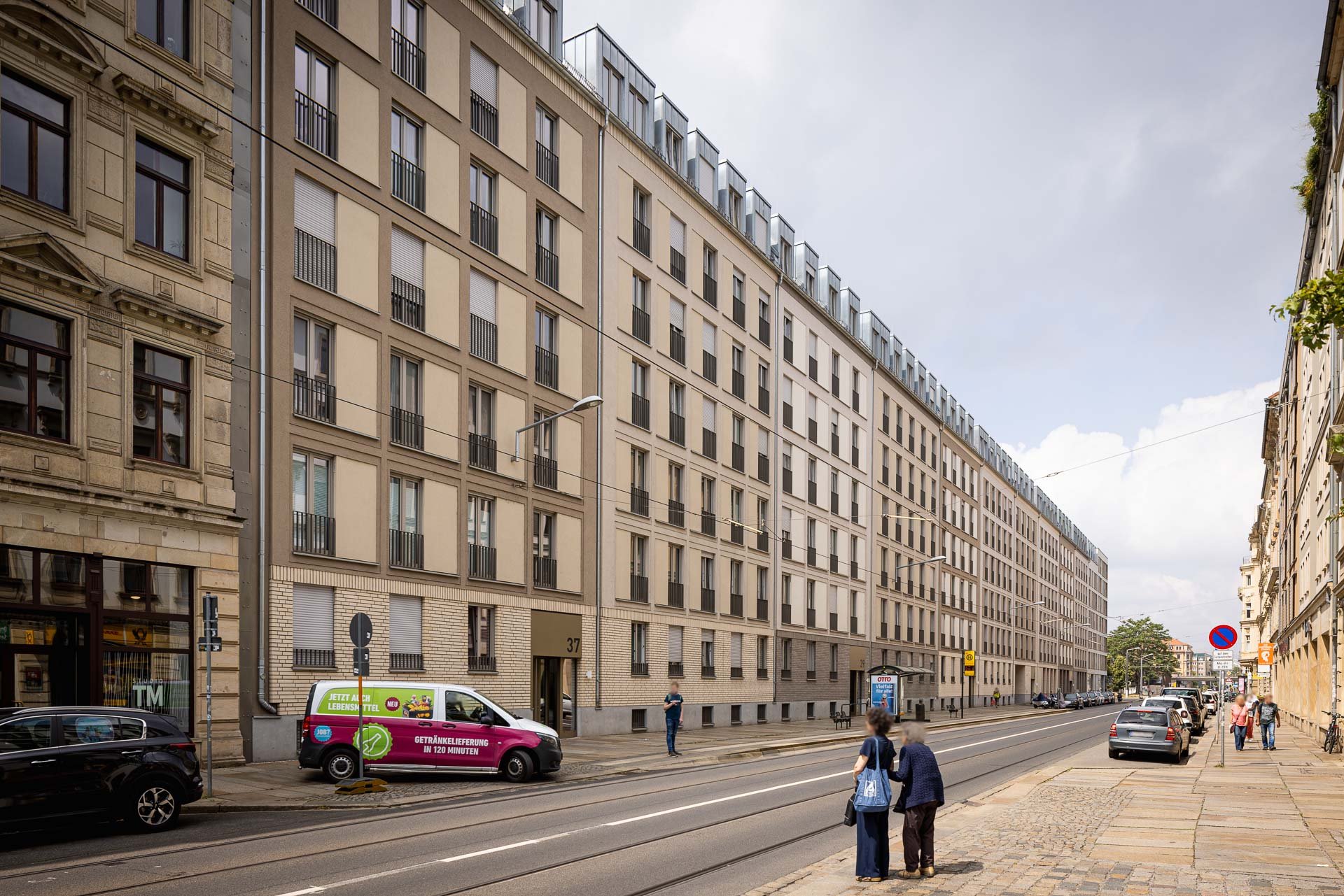
Image gallery: Selection of urban landscape photographs

View from the Marienbrücke in the direction of the old town, Elberadweg, Palaisgarten, Innere Neustadt, 51°3'39.4416" N 13°44'4.668" E, 109m above sea level, 07.10.2022, 15:32

Theaterplatz 1, King Johann Monument, Innere Altstadt, 51°3'13.9356" N 13°44'9.1896" E, 115 m above sea level, 14.06.2022, 17:11

Neumarkt, Innere Altstadt, 51°3'5.1048" N 13°44'25.8324" E, 117 m above sea level, 28.06.2022, 15:26

Augustusstraße 1, Verkehrsmuseum, Innere Altstadt, 51°3'6.912" N 13°44'22.56" E, 117 m above sea level, 28.06.2022, 15:20

Schloßstraße 2, Kulturpalast, Innere Altstadt, 51°3'4.9752" N 13°44'16.1124" E, 115 m above sea level, 19.07.2022, 07:08

Schießgasse 7, Police Headquarters Dresden, Innere Altstadt, 51°3'4.8096" N 13°44'39.5592" E, 116m above sea level, 14.06.2022, 17:56

Sophienstraße, Dresdner Zwinger, Innere Altstadt, 51°3'12.7764" N 13°44'4.7688" E, 116m above sea level, 14.06.2022, 17:04

An der Kreuzkirche 6, Kreuzkirche, Innere Altstadt, 51°2'56.3604" N 13°44'20.0472" E, 114m above sea level, 19.07.2022, 07:19

Brühlsche Terrasse, Planet Monument, Innere Altstadt, 51°3'12.438" N 13°44'28.8204" E, 117m above sea level, 19.07.2022, 06:56

Schlesischer Platz, Dresden-Neustadt train station, Innere Neustadt, 51°3'56.1024" N 13°44'27.541" E, 115m above sea level, 07.10.2022, 12:44

View towards the main train station from the Budapester Straße bridge, Wilsdruffer Vorstadt, 51°2'35.2608" N 13°43'26.4792" E, 119m above sea level, 07.10.2022, 13:24

Hauptstraße 18, Innere Neustadt, 51°3'33.0918" N 13°44'35.1794" E, 114m above sea level, 07.10.2022, 14:57

Lingnerallee, skate park, Pirnaische Vorstadt, 51°2'45.654" N 13°44'47.22" E, 114m above sea level, 19.07.2022, 07:47

Lingnerplatz 1, German Hygiene Museum, Seevorstadt, 51°2'39.6132" N 13°44'48.8652" E, 116m above sea level, 19.07.2022, 07:53

Lennéstraße 12, Rudolf-Harbig-Stadion, Seevorstadt, 51°2'25.0692" N 13°44'53.4804" E, 115m above sea level, 19.07.2022, 08:34

Lennéstraße 1, Gläserne Manufaktur, Seevorstadt, 51°2'40.4376" N 13°45'18.5184" E, 111m above sea level, 19.07.2022, 11:35

Tiergartenstraße 1, Zoo, Seevorstadt, 51°2'20.8788" N 13°45'9.846" E, 117m above sea level, 19.07.2022, 09:16

Großer Garten, Palaisteich, Palais, Seevorstadt, 51°2'12.0948" N 13°45'57.0384" E, 118m above sea level, 19.07.2022, 10:55

Permoserstraße 7, Johannstadt-Süd, 51°2'56.8932" N 13°45'46.44" E, 118m above sea level, 14.06.2022, 14:11

Schönaer Str. 10, Großzschachwitz, 51°0'12.8154" N 13°50'16.0581" E, 119m above sea level, 10.10.2021, 14:14

Rathener Str. 115, Großzschachwitz, 51°0'4.698" N 13°49'54.522" E, 120m above sea level, 10.10.2021, 14:50

Wundtstraße 7, Südvorstadt-Ost, 51°1'44.1048" N 13°44'54.0564" E, 135m above sea level, 27.10.2022, 13:37

Löbtauer Bridge, B173, Vereinigte Weißeritz, Löbtau-Nord, 51°2'37.5187" N 13°42'17.3193" E, 128m above sea level, 12.06.2022, 14:31

Lockwitzgrund 55, Lockwitz, 50°58'54.6924" N 13°47'46.1292" E, 145m above sea level, 11.04.2022, 09:44

Oederaner Str. 21, Nossener Brücke heating plant, Löbtau-Nord, 51°2'32.3376" N 13°42'27.648" E, 124m above sea level, 12.06.2022, 15:08

Dresden Airport, beacon, landing airplane, Hellerau, 51°7'21.432" N 13°45'6.6384" E, 211m above sea level, 11.10.2022, 09:12

Riegelplatz 2, 43rd Thomas Müntzer Elementary School, Riegelplatz stop, Kaditz, 51°5'1.4136" N 13°41'12.6348" E, 110m above sea level, 13.04.2022, 09:55

An der Heilandskirche 3, Heilandskirche, Cotta, 51°3'24.5124" N 13°40'53.3244" E, 130m above sea level, 02.03.2022, 14:06

August-Böckstiegel-Straße 2, Pillnitz Palace & Park, Bergpalais, Hosterwitz, 51°0'33.8656" N 13°52'15.069" E, 117m above sea level, 04.06.2023, 13:13

Messering 20, Kühlhaus, Friedrichstadt, 51°4'21.7956" N 13°42'51.0264" E, 111m above sea level, 12.06.2022, 16:59

Dresden Messe tram stop, Friedrichstadt, 51°4'14.682" N 13°42'51.3972" E, 117m above sea level, 12.06.2022, 17:08

Löbtauer Straße, Cottaer Straße tram stop, Friedrichstadt, 51°3'2.3004" N 13°42'48.4848" E, 119m above sea level, 12.06.2022, 13:02

Trachenberger Str. 40, Dresdner Verkehrsbetriebe, Trachenberge depot, Pieschen-Nord, 51°5'9.1968" N 13°43'47.118" E, 112m above sea level, 10.02.2022, 11:13

Kraftwerk Mitte 1, Theater Junge Generation, Wilsdruffer Vorstadt, 51°3'7.5024" N 13°43'20.1288" E, 116m above sea level, 08.03.2022, 13:56

Schäferstraße 35, Friedrichstadt, 51°3'19.9908" N 13°43'1.632" E, 114m above sea level, 12.06.2022, 12:45

Eibenstocker Straße 111, Striesen-Ost, 51°2'3.2747" N 13°48'10.9473" E, 114m above sea level, 09.05.2023, 14:19

Green space between Lili-Elbe-Straße and Arnoldstraße, Johannstadt, 51°3'14.76" N 13°46'6.3336" E, 115m above sea level, 14.06.2022, 19:43

Schäferstraße 31, Friedrichstadt, 51°3'19.3248" N 13°43'3.8424" E, 114m above sea level, 12.06.2022, 12:46
Schweriner Str. 37, Wilsdruffer Vorstadt, 51°3'9.7668" N 13°43'34.5396" E, 116m above sea level, 28.06.2022, 11:49

Walter-Arnold-Straße 3, Strehlen, 51°1'2.3412" N 13°46'49.5588" E, 124m above sea level, 05.05.2022, 14:08

Nöthnitzer Straße 44, Fraunhofer Institute, Räcknitz, 51°1'33.744" N 13°43'13.9152" E, 154m above sea level, 30.09.2022, 10:29

Kipsdorfer Str. 153, 32nd secondary school, Tolkewitz, 51°2'5.8257" N 13°48'55.5527" E, 116m above sea level, 04.05.2023, 10:14

Area of the Alter Leipziger Bahnhof, Leipziger Vorstadt, 51°4'4.6185" N 13°44'7.8238" E, 110m above sea level, 09.05.2022, 13:39

Berthelsdorfer Weg 2, former Schrön nursery, Tolkewitz, 51°1'59.5186" N 13°48'44.9489" E, 115m above sea level, 04.05.2023, 11:12

Wolfgang-Mischnick-Str. 5, Albertstadt, 51°4'25.7606" N 13°46'2.2139" E, 135m above sea level, 07.10.2022, 09:43

Gerokstraße 13, Johannstadt, 51°3'13.0572" N 13°45'40.9356" E, 114m above sea level, 14.06.2022, 14.43

Mommsenstraße 6, Technische Universität, Fritz-Foerster-Bau, Südvorstadt, 51°1'39.9792" N 13°43'45.066" E, 153m above sea level, 07.10.2022, 13:39

Grundstraße 127, Loschwitz, 51°3'32.2196" N 13°49'51.673" E, 212m above sea level, 30.04.2023, 16:35

Hermann-Seidel-Straße, War Memorial, Laubegast, 51°1'32.352" N 13°49'54.102" E, 114m above sea level, 03.11.2021, 11:23

Berthold-Haupt-Straße 37, Kleinzschachwitz, 51°0'31.608" N 13°51'28.7208" E, 117m above sea level, 10.10.2021, 12:38

Altkaditz 23, Kaditz, 51°4'58.2053" N 13°40'17.8582" E, 113m above sea level, 02.03.2022, 09:38

Altübigau 4, Mickten, 51°4'17.3532" N 13°42'0.8172" E, 105m above sea level, 02.03.2022, 11:17

Blaues Wunder, Blasewitz, 51°3'5.9639" N 13°48'37.8562" E, 118m above sea level, 21.04.20223, 11:30

Neustädter Hafen, Accommodation ship, Leipziger Vorstadt, 51°3'53.6303" N 13°43'54.6213" E, 107m above sea level, 09.05.2022, 13:54

Bautzner Str. 130, Albrechtsberg Palace, Loschwitz, 51°3'53.5176" N 13°47'39.4695" E, 126m above sea level, 30.04.2023, 09:56

Bautzner Str. 132, Lingner Palace, Loschwitz, 51°3'50.9118" N 13°47'51.1668" E, 122m above sea level, 30.04.2023, 10:18

Waldpark Kleinzschachwitz, Playground, Kleinzschachwitz, 51°0'27.5652" N 13°51'2.7108" E, 115m above sea level, 10.10.2021, 11:46

Playground Rähnitzer Mühlweg, Weixdorf, 51°8'21.0192" N 13°47'27.4956" E, 197m above sea level, 15.10.2024, 16:13

Leubnitzer Höhe, Adventure playground Leubnitzer Höhe, Leubnitz-Neuostra, 51°0'23.7384" N 13°45'55.9728" E, 181m above sea level, 05.05.2022, 10:43

Dresdner Heide, Haarweidenstausee, Dresdner Heide, 51°5'4.8729" N 13°52'8.323" E, 246m above sea level, 02.06.2023, 12:29

Dresdner Heide, Prießnitz waterfall, Dresdner Heide, 51°6'44.7204" N 13°48'2.1196" E, 208m above sea level, 02.06.2023, 15:09

Dresdner Heide, Alte Drei, Dresdner Heide, 51°5'17.0581" N 13°49'31.726" E, 244m above sea level, 02.06.2023, 13:58

Northwestern foothills of the Dresdner Heide, Klotzsche, 51°7'43.446" N 13°47'45.906" E, 194m above sea level, 11.10.2022, 10:52

Kaitzer Höhe, Coschütz, 51°0'36.072" N 13°42'39.3372" E, 236m above sea level, 13.10.2022, 09:52

Leitenweg, View towards Weinbergkirche, Hosterwitz, 51°0'45.828" N 13°52'36.1884" E, 168m above sea level, 04.06.2023, 15:57

Fährstelle Laubegast, Hosterwitz, 51°1'55.8234" N 13°50'21.7125" E, 107m above sea level, 30.05.2023, 19:05

Sierksstraße 2, Upper station of the Suspension Railway, Loschwitz, 51°3'15.4746" N 13°49'12.4873" E, 198m above sea level, 26.09.2022, 18:33
2. Historical Classification and Problem Solving of Previous Documentation of the cityscape
The urban landscape documentation in Dresden builds on a tradition spanning over 200 years. As early as 1905, the city archives, under the direction of Otto Richter, published the illustrated book "Dresden sonst und jetzt" (Dresden Then and Now). This contained 50 double images that juxtaposed etchings from the early 19th century with photographs from the early 20th century. This method made the city's transformation visible and laid the foundation for regular documentation.
Until the fall of the Berlin Wall in 1990, urban landscape photography in Dresden was continuously pursued. After that, however, the city's photo stations were gradually dismantled, and the documentation work was transferred to administrative employees. These employees used compact cameras and later smartphones, which led to numerous challenges: poor image quality, enormous amounts of data since the beginning of the digital age, lack of keywording, and only sporadic documentation in connection with current projects.
Another disadvantage was the inefficient use of resources: a complete documentation of the city by the administration would have generated 80 times the amount of data compared to our project. In addition, images that are not keyworded are often lost in the amount of data and are rarely used again. A similar problem exists when purchasing existing image collections: Analog images must first be digitized, image rights clarified, and the images enriched with metadata to make them findable in digital archives. These are just some of the challenges we faced in this project, and we have found solutions for each of these points.
Today, our work not only serves as a continuation of this tradition but also sets new standards. It offers a high-quality, systematically keyworded image archive that serves as a basis for urban planning, historical research, and public relations. The size and depth of the data collected make this project unique.
Image gallery: Recreated historical cityscapes of Dresden

Japanese Palais, around 1820

Japanese Palais, 1900

Palaisplatz 11, Japanese Palais, Innere Neustadt, 51°3'36.0072" N 13°44'14.2008" E, 110m above sea level, 07.10.2022, 15:42

Altkaditz, 1911

Altkaditz 30, Kaditz, 51°4'59.0772" N 13°40'18.5916" E, 113m above sea level, 02.03.2022, 09:36

Radetzkystraße, 1912

Einsteinstraße 3, Südvorstadt-Ost, 51°1'50.1852" N 13°43'59.6064" E, 128m above sea level, 02.03.2022, 17:38

Sophienkirche, around 1820

Sophienkirche, around 1900

Sophienstraße 2, Denkraum Sophienkirche, Innere Altstadt, 51°3'5.004" N 13°44'5.5644" E, 114m above sea level, 14.06.2022, 16:55

Annenkirche, 1949

Annenstraße 9, Dresden International School, Wilsdruffer Vorstadt, 51°2'59.2872" N 13°43'45.6888" E, 111m above sea level, 08.03.2022, 13:08

Zeughausplatz, around 1820

Zeughausplatz, around 1900

Tzschirnerplatz 3-5, Kurländer Palais, Innere Altstadt, 51°3'5.2344" N 13°44'41.7768" E, 110m above sea level, 14.06.2022, 17:58

Taschenberg Square/ Sophienstrasse, around 1820

Taschenberg Square/ Sophienstrasse, around 1900

Taschenberg Square / Sophienstrasse, Innere Altstadt, 51°3'9.5688" N 13°44'6.4752" E, 114m above sea level, 28.06.2022, 13:07

The Neumarkt, around 1820

The Neumarkt, around 1900

Neumarkt, Innere Altstadt, 51°3'5.1048" N 13°44'25.8324" E, 113m above sea level, 28.06.2022, 15:26
3. The Preparation: Structured Planning
The successful implementation of the project begins with structured planning, ranging from the development of a clear image concept to detailed coordination with the city archives.
Development of an Image Concept: A consistent image style forms the basis of the project. The photographs are characterized by a clear visual language with natural coloring. Bright, clear, and colorful images combine the ability to analyze the image content with an appealing appearance that is also suitable for public relations. A distortion-free, uniform focal length ensures a realistic representation of the cityscape, while the choice of suitable camera technology ensures a good balance of high resolution, large dynamic range, and efficient data volume.
Definition of the Data Structure: The images are systematically named and exported in four different resolutions. From lossless convertible 16-bit formats for long-term archiving to adapted sizes for print and web use, every requirement is covered. In addition, a tabular listing of all metadata is exported to facilitate integration into the image database of the city of Dresden.
Collaboration with the City Archives: In close coordination with the city archives, historical image material is integrated into the shooting schedule to enable before-and-after shots. In an overview map, we mark mandatory objects and points of public interest for transparent planning with all project participants. On this basis, concrete shooting routes are derived, which ensure efficient and comprehensive documentation.
4. The Capture and Editing: Step by Step and Image by Image
Systematic Capture: Every day I systematically capture all streets and relevant objects. On average, this results in about 100 images per day, combined with around 25,000 steps. With an area of 328 square kilometers, Dresden is the fourth largest city in Germany and impresses with its diverse geographical location. The city lies in the Elbe Valley, nestled between the Eastern Ore Mountains, the Lusatian Granite Plateau and the Elbe Sandstone Mountains. In addition to the Elbe, which flows through the city area for a length of 30 kilometers, the Weißeritz and Prießnitz rivers shape the hydrographic network.
Dresden has 7,341 hectares of forest and 676 hectares of water areas. The city is home to four nature reserves, ten landscape conservation areas, and 138 listed gardens, avenues, and parks. With a total of 178 schools, 11 hospitals, 224 playgrounds, 73 churches, 369 allotment associations, and 13 castles and palaces, Dresden presents itself as a city with a wide variety of urban and natural structures, which we documented in two production phases over 23 months.
Prioritizing Topics: We place special emphasis on public buildings such as schools, daycare centers, and administrative buildings. At the same time, we ensure that all districts and localities are covered comprehensively. The project is structured in two clearly defined production phases: 20 months are dedicated to the urban area, followed by 3 months of intensive work in the Dresden localities.
Each of the ten districts is treated equally and documented in approximately 800 images. We set individual priorities to highlight the respective district structure and its special features. This equality ensures a comprehensive and balanced cityscape that reflects the diversity and identity of all facets of Dresden.
Consistent Image Quality: To ensure consistent image quality, we primarily document the city between April and November in sunny weather. This optimizes the usability of the images for public relations. The photos maintain a uniform style across seasons and weather conditions.
Image Editing and Anonymization: Each day of shooting is followed by a day for image import, sorting, keywording, editing, and anonymization. Our team works decentrally and cloud-based from various cities across Germany to make processing efficient. A total of 20,000 images are created, in which we manually anonymize approximately 60,000 license plates and people. Each GPS coordinate is manually checked and assigned to the nearest building. We ensure that the captured metadata reflects the exact address and geographical position to facilitate integration into digital city archives. At the same time, all image data is comprehensively tagged and exported in a tabular format to ensure its findability and usability for future projects.
Transparency Throughout the Entire Process: Both the city archive and the district offices can follow the progress of the project in real-time via cloud access to our image database. This access allows all participants to continuously view the status of the documentation and provide feedback. This ensures that the project is always aligned with the requirements of the later users over three and a half years. In addition, the Dresden City Archives organized an interim meeting every six months, in which we presented completed districts and clarified open questions.
Image gallery: Behind the scenes of cityscape photography

Albrecht Voss during his forays through the city of Dresden, Copyright Martin Neuhof

Albrecht Voss during his forays through the city of Dresden, Copyright Martin Neuhof

Albrecht Voss during his forays through the city of Dresden, Copyright Martin Neuhof

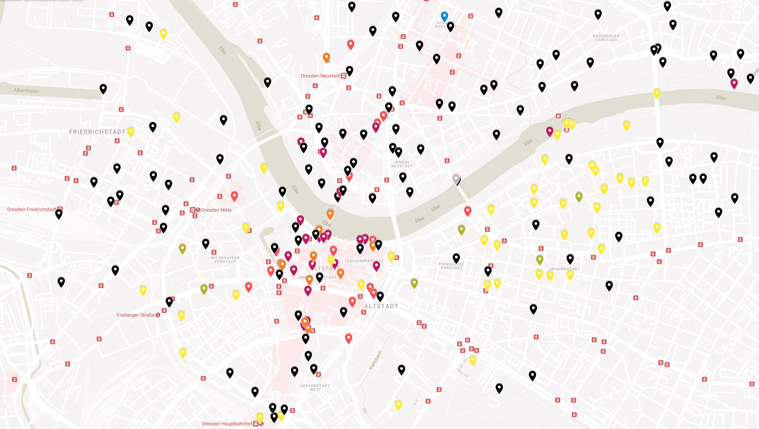
Overview map of all realized photographs in Dresden including the surrounding areas

Detailed map with recording points in the Blasewitz district

Albrecht Voss during image processing, Copyright Martin Neuhof

Before/ After view of image processing
5. Results: A Resource for Generations
The project delivers over 10,000 high-quality images, fully enriched with metadata, offering diverse applications. These include planning processes, public relations, and scientific research. The images are presented in public exhibitions and integrated into digital archives, making them accessible to both the city administration and the public.
Previous Use: To conclude the project, the Dresden City Archives organized an exhibition on its premises. It was opened by the cultural mayor Annekatrin Klepsch and the head of the Dresden City Archives, Prof. Thomas Kübler, and is one of the most successful exhibitions in the history of the City Archives. The before-and-after comparisons, which impressively documented the city's transformation, were particularly popular. Due to the great interest, the exhibition, which was structured according to districts, was extended to a total of six months.
After the images were transferred to the digital database, over 200,000 citizens accessed them in the first year and used the images in a variety of ways. Wikipedia integrated the entire image collection into Wikimedia and thanked them for the significant gain in high-quality content. The images are also shown in numerous individual exhibitions in the districts and will soon embellish the rooms of the new Dresden City Forum.
Future and Continuation: The images form the basis of a new uniform image database for the Dresden city administration, which can be used by offices such as the urban planning office, the building construction office and the monument preservation office. This database enables easy searching both via the database itself and via the thematic city map, which offers direct access to images in specific urban areas.
A continuous continuation of the cityscape documentation has already been initiated. In the coming years, we will document the changes in special development areas of Dresden in order to visualize and archive the dynamics of urban development.
The project also represents a milestone for the city of Dresden: it is the first project to be financed through cost-sharing at the entire municipal level, thereby initiating cross-district cooperation. Supported by funding from the European Union, this project demonstrates how sustainable added value can be created through cooperation and innovative approaches.

Conclusion
Together with my team and the Dresden City Archives under the direction of Prof. Thomas Kübler, we have taken cityscape documentation to a new level. In 23 months, we documented the entire urban area of Dresden, Germany's fourth largest city, in over 10,000 images. Each image contains a detailed set of filterable metadata, personal rights were protected, all project participants were always transparently involved, and each sub-area was completed on time and within the agreed budget. All images are available to the public under the Creative Commons License CC-BY-SA 4.0 without restrictions and free of charge.
Would you like to have your own city, municipality, nature reserves, castles or churches documented? We will accompany you from planning to implementation to the exploitation of your project - always personally, with commitment and flexibility, whether in Germany, Europe or worldwide. Contact us to make your vision a reality together.
Thanks to the Supporters
My special thanks go to the team around Prof. Dr. Kübler from the Dresden City Archives for their courage to launch such a project, for their trust in our work, their preparation and expert support, and the impressive exhibition that has decisively shaped this project. I would also like to thank the city and local councils who made this project possible for their participation and funding.
A big thank you goes to our partner companies Adobe Germany, ARCA-SWISS, Gitzo, Oberwerth and Vallerret, who supported us with high-quality photo equipment and shared the project with over a million followers. Without their material support, the implementation of this project in this quality would not have been possible.
Finally, I would like to thank my team, my employees and interns for their dedicated participation. Special thanks also go to Martin Neuhof and Flightseeing Dresden for documenting my work. Their contributions have made this project what it is today: a milestone in cityscape documentation.


